-
A mural depicting two volcanoes near Catal Hyuk, an ancient community which was located in what is now Turkey, is considered to be the oldest map. Image address:http://cartographic-images.net/Cartographic_Images/100_Town_Plan_from_Catal_Hyuk_files/droppedImage_1.jpg
-
-
-
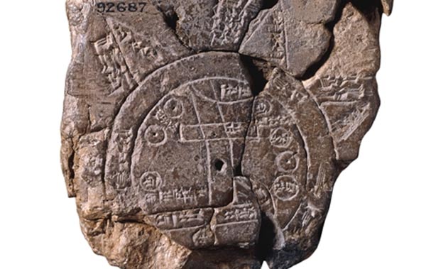
This small map made on a clay tablet shows how the Babylonians viewed their world. Image address: http://www.ancient-origins.net/sites/default/files/field/image/babylonian-map-of-world.jpg
-
-
-
Hipparchus was a Greek mathematician, astronomer and geographer who created a grid on a globe by placing lines that were parallel to the equator at equal intervals, and then marking off lines that were at right angles to these latitude lines. Source: https://www.ancient.eu/Hipparchus_of_Nicea/
-
Ptolemy, an ancient Greek geographer and astronomer, created a map, which included coordinates for 8,000 locations. Image address: http://www.bl.uk/learning/timeline/external/ptolemy-lg.jpg
-
Al-Khwarizmi was an ancient Persian mathematician, astronomer and geographer. He revised Ptolemy's views of the world, and was instrumental in the creation of the first map of the world.
Source: http://www.khwarizmi.org/pages/muhammad-bin-musa-al-khwarizmi -
Al-Biruni, an ancient Persian scholar, developed techniques using triangulation to measure the earth and distances on it.
Source: http://www-groups.dcs.st-and.ac.uk/history/Biographies/Al-Biruni.html
Image address: http://thescientificodyssey.typepad.com/.a/6a01b8d0788cce970c01b8d1ae4a2d970c-pi -
Abraham Cresques, a master map-maker, along with his son, drew six nautical maps based on compass directions. These were compiled in the Catalan Atlas, which contained a world map.
Source:https://en.wikipedia.org/wiki/Abraham_Cresques -
This is a navigational tool that allows for a precise measurement of the angular distance between two visible objects. Source: https://en.wikipedia.org/wiki/Sextant
-
-
Greenwich was chosen by the International Meridian Conference. Image address: http://news.bbc.co.uk/2/hi/8266883.stm
-
Detailed and highly accurate web-based maps are produced using information from aerial and satellite imagery, as well as geographic information systems.


Looking for a timeline maker?
Create timelines for projects, roadmaps, history, lessons, legal cases, and stories with Timetoast. Timetoast is a timeline maker for work, school, research, and stories.