
-
Shorelines are areas where the ocean touches land and it is as simple as that. When the earth was formed it was covered with water and had a single major continent which was called pangea. At that time and even today the ocean touches the edges of the continents land. Now that means wherever the ocean touches the land it is a shoreline. From the very beginning there has always been a shoreline.
-
Image linkA fall zone or what it is also known as a fall line, is a stream that once started out small way back when pangea was still happening. As the techtonic plates shifted and moved the stream became bigger. That small stream came to be called a fall line which goes starts up in Virgina and goes straight down through NC, SC and Georgia. The fall line continues to get bigger because as the water flows it erodes the rocks around and below which lowers the elevation and it begins to flow south.
-
Image LinkIt all began around 420 million years ago when pangea was starting to form. As pangea began to take form the Appalachian mountains was already brginning to form. 120 million years later the tectonic plates shifted and crashed into each other and became what is known as pangea. When pangea came to be and the plates came together, the other mountains tha formed in other places came together and formed what is know the Appalachian Mountains. At one point they were bigger than the Alps and Rocky Mt.
-
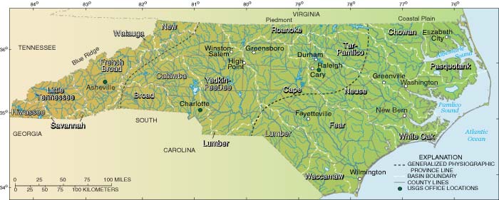
Photo linkRiver basisn's are littel rivers that lead that lead the water to larger rivers that lead to the ocean. We live in a river basin because the ground we live on obsorbs water and that water will always travel to another place in the world and that is most likely be a river. A river basin is formed by erosion of the soil because all of the rain fall builds up on the soil and it begins to flow towards an already existing river because of the evelation of the area that its in.
-
for the photoRiver Valley's are rivers that are between two hills or mountains. As the land crashes together through techtonic shift the land is pushed up and there is a crease between the two. When Pangea came to be and so did the mountains. As the land formed the land began to crack and the ocean then leaked into those cracks and the water erode the land until it reached the place between the two mountains.
-
the information barrowedto the pictureBarrier Islands began during the end of the ice age and scientists believe that when the ice started to melt and fall into the ocean they would push sediment and would cause them to build up on to each other. This then created barrier island which is pretty much a giant pile of sand and other sediment in the middle of the ocean. It continues to change because of the waves and storms push the sediment around causing the shap of the island to change drastically.


A list shows items. A timeline shows sequence.
Use Timetoast to make dates, milestones, and turning points easier to understand in a clear visual format. Timetoast is a timeline maker for work, school, research, and stories.